
Grabówki topographic map
Interactive map
Click on the map to display elevation.
About this map
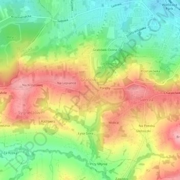
Name: Grabówki topographic map, elevation, terrain.
Average elevation: 298 m
Minimum elevation: 228 m
Maximum elevation: 372 m
Other topographic maps
Click on a map to view its topography, its elevation and its terrain.
Niepołomice
Poland > Lesser Poland Voivodeship > Wieliczka County > Niepołomice
Niepołomice, gmina Niepołomice, Wieliczka County, Lesser Poland Voivodeship, 32-005, Poland
Average elevation: 202 m
Wieliczka
Poland > Lesser Poland Voivodeship > Wieliczka County
Wieliczka, gmina Wieliczka, Wieliczka County, Lesser Poland Voivodeship, 32-020, Poland
Average elevation: 270 m