
Fish Lake topographic map
Click on the map to display elevation.
About this map
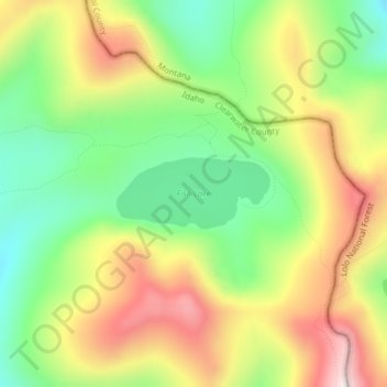
Name: Fish Lake topographic map, elevation, terrain.
Location: Fish Lake, Clearwater County, Idaho, United States (46.81491 -114.92015 46.81990 -114.90448)
Average elevation: 1,893 m
Minimum elevation: 1,691 m
Maximum elevation: 2,138 m
Other topographic maps
Click on a map to view its topography, its elevation and its terrain.
Weippe
United States > Idaho > Clearwater County
Weippe is located at 46°22′42″N 115°56′23″W / 46.37833°N 115.93972°W / 46.37833; -115.93972 (46.378219, -115.939825), at an elevation of 3,015 feet (919 m) above sea level.
Average elevation: 926 m
Orofino
United States > Idaho > Clearwater County
The city has a climate typical of low-elevation areas in Idaho and eastern Washington. Orofino has a dry-summer continental climate (Köppen Dsb). Due to the warm summers, it nearly qualifies as a continental Mediterranean climate (Dsa). Idaho's all-time highest temperature of 118 °F or 47.8 °C was recorded…
Average elevation: 633 m
Orofino
United States > Idaho > Clearwater County
The city has a climate typical of low-elevation areas in Idaho and eastern Washington. Orofino has a dry-summer continental climate (Köppen Dsb). Due to the warm summers, it nearly qualifies as a continental Mediterranean climate (Dsa). Idaho’s all-time highest temperature of 118 °F or 47.8 °C was…
Average elevation: 633 m
Orofino
United States > Idaho > Clearwater County
The city has a climate typical of low-elevation areas in Idaho and eastern Washington. Orofino has a dry-summer continental climate (Köppen Dsb). Due to the warm summers, it nearly qualifies as a continental Mediterranean climate (Dsa). Idaho's all-time highest temperature of 118 °F or 47.8 °C was recorded…
Average elevation: 633 m