Geolocate

Canton topographic map

Click on the map to display elevation.

Canton

Canton is located at an elevation of 1,060 feet (323 m).[39] Nimishillen Creek and its East, Middle and West Branches flow through the city.[40]

Wikipedia (CC-BY-SA 3.0)

About this map

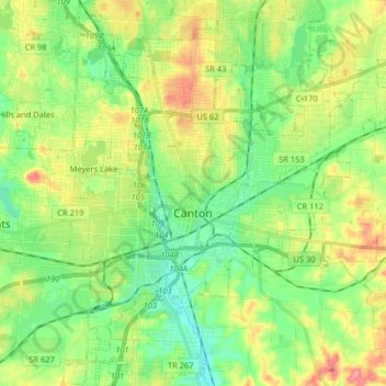
Name: Canton topographic map, elevation, terrain.

Location: Canton, Stark County, Ohio, United States (40.74366 -81.42928 40.86586 -81.28474)

Average elevation: 335 m

Minimum elevation: 301 m

Maximum elevation: 392 m

Other topographic maps

Click on a map to view its topography, its elevation and its terrain.

Sippo Heights

United States > Ohio > Stark County > Massillon

Average elevation: 318 m

Mount Pleasant

United States > Ohio > Stark County

Average elevation: 352 m

Deer Creek

United States > Ohio > Stark County > Lexington

Average elevation: 319 m

Lake Cable

United States > Ohio > Stark County

Average elevation: 340 m

North Industry

United States > Ohio > Stark County

Average elevation: 333 m

New Franklin

United States > Ohio > Stark County

Average elevation: 365 m

Gear up for your next adventure:

🛰️Outdoor GPS Navigation - Navigation devices for remote and off-grid areas
📻Hand-Crank Emergency Radios - Stay updated on weather warnings in remote areas
🧭Emergency Beacons - Safety beacons for remote outdoor locations
🧷Tenacious Repair Tape - Instant fix for torn tents, jackets, or dry bags
Lightweight Solo Tents - Backpacking tents designed for wild camping in the UK highlands

As an Amazon Associate, this site earns from qualifying purchases at no extra cost to you.