
Make a donation
Gear up for your next adventure:
As an Amazon Associate, this site earns from qualifying purchases at no extra cost to you.
Lake Cable topographic map
Click on the map to display elevation.
Make a donation
Gear up for your next adventure:
As an Amazon Associate, this site earns from qualifying purchases at no extra cost to you.
About this map
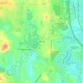
Name: Lake Cable topographic map, elevation, terrain.
Average elevation: 340 m
Minimum elevation: 317 m
Maximum elevation: 380 m
Make a donation
Gear up for your next adventure:
As an Amazon Associate, this site earns from qualifying purchases at no extra cost to you.
Other topographic maps
Click on a map to view its topography, its elevation and its terrain.
Canton
United States > Ohio > Stark County
Canton is located at an elevation of 1,060 feet (323 m). Nimishillen Creek and its East, Middle and West Branches flow through the city.
Average elevation: 335 m
Make a donation
Gear up for your next adventure:
As an Amazon Associate, this site earns from qualifying purchases at no extra cost to you.
Make a donation
Gear up for your next adventure:
As an Amazon Associate, this site earns from qualifying purchases at no extra cost to you.
Make a donation
Gear up for your next adventure:
As an Amazon Associate, this site earns from qualifying purchases at no extra cost to you.
Canton
United States > Ohio > Stark County
Canton is located at an elevation of 1,060 feet (323 m). Nimishillen Creek and its East, Middle and West Branches flow through the city.
Average elevation: 335 m
Make a donation
Gear up for your next adventure:
As an Amazon Associate, this site earns from qualifying purchases at no extra cost to you.
Canton
United States > Ohio > Stark County
Canton is located at an elevation of 1,060 feet (323 m).[39] Nimishillen Creek and its East, Middle and West Branches flow through the city.[40]
Average elevation: 335 m
Make a donation
Gear up for your next adventure:
As an Amazon Associate, this site earns from qualifying purchases at no extra cost to you.