
Bhamdoun topographic map
Interactive map
Click on the map to display elevation.
Bhamdoun
Bhamdoun (Arabic: بحمدون), is a town in Lebanon 23 km (14 mi) from Beirut on the main road that leads to Damascus and in the suburbs of the main tourist city of Aley, lying at an altitude of 1,150 m (3,770 ft) above the Lamartine valley. Two separate villages compose the town, Bhamdoun-el-mhatta (literally meaning "Bhamdoun the station") and Bhamdoun-el-day'aa ("Bhamdoun the village"). A railroad used to link Bhamdoun to Beirut with the train station being a prominent feature of the town for many years. The station and railroad were eventually abandoned when cars became more popular.
About this map
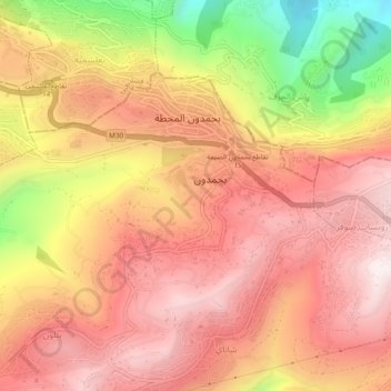
Name: Bhamdoun topographic map, elevation, terrain.
Location: Bhamdoun, Aley District, Mount Lebanon Governorate, Lebanon (33.76307 35.61945 33.84307 35.69945)
Average elevation: 930 m
Minimum elevation: 316 m
Maximum elevation: 1,433 m
Other topographic maps
Click on a map to view its topography, its elevation and its terrain.
Baskinta
Lebanon > Mount Lebanon Governorate
Baskinta (Arabic: بسكنتا) is a Lebanese village situated at an altitude ranging from 1250 metres above sea level and climbs up to approximately 1800 meters of height at Qanat Bakish, making it one of the highest villages of Lebanon. It is located 43 kilometers north east of Beirut.
Average elevation: 1,396 m
Ain Saadeh
Lebanon > Mount Lebanon Governorate
The average annual rainfall is 825 millimetres (32.5 in), with the large majority of it falling from October to April. Much of the autumn and spring rain falls in heavy downpours on a limited number of days, but in winter it is spread more evenly over many days. Summer receives very little rainfall, if any.…
Average elevation: 335 m
Beit Mery
Lebanon > Mount Lebanon Governorate
1) Beit Mery I is on the right bank of the Beirut River, south southwest of the town at an altitude of approximately 125 metres (410 ft) above sea level. It was found by Jesuit Father Dillenseger who determined it to be an Acheulean site. The material was donated to the Saint Joseph University by the French…
Average elevation: 460 m
Aley
Lebanon > Mount Lebanon Governorate
The word "Aley" means "high place" in Arabic and in Aramaic, referring to the city's high altitude above sea level (from 600m up to 950m).
Average elevation: 775 m
Antelias
Lebanon > Mount Lebanon Governorate
The municipality of Antelias - Naqqach is located in the Kaza of Matn in Mount Lebanon, one of the eight mohafazats (governorates) of Lebanon. Antelias - Naqqach is 8 kilometers (4.9712 mi) from Beyrouth (Beirut), the capital of Lebanon. Its elevation is 10 meters (32.81 ft; 10.936 yd) above sea level.…
Average elevation: 65 m
Aley
Lebanon > Mount Lebanon Governorate
The word "Aley" means "high place" in Arabic and in Aramaic, referring to the city's high altitude above sea level (from 600m up to 950m).
Average elevation: 775 m