
Make a donation
Gear up for your next adventure:
As an Amazon Associate, this site earns from qualifying purchases at no extra cost to you.
Great Dividing Range topographic map
Click on the map to display elevation.
Make a donation
Gear up for your next adventure:
As an Amazon Associate, this site earns from qualifying purchases at no extra cost to you.
Great Dividing Range
The Great Dividing Range, also known as the East Australian Cordillera or the Eastern Highlands, is a cordillera system in eastern Australia consisting of an expansive collection of mountain ranges, plateaus and rolling hills, that runs roughly parallel to the east coast of Australia and forms the fifth-longest land-based mountain chain in the world, and the longest entirely within a single country. It is mainland Australia's most substantial topographic feature and serves as the definitive watershed for the river systems in eastern Australia, hence the name.
Make a donation
Gear up for your next adventure:
As an Amazon Associate, this site earns from qualifying purchases at no extra cost to you.
About this map
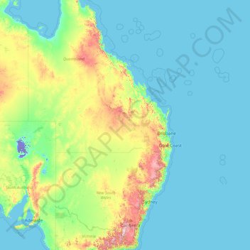
Name: Great Dividing Range topographic map, elevation, terrain.
Location: Great Dividing Range, Australia (-37.82225 142.45440 -13.66768 152.52520)
Average elevation: 117 m
Minimum elevation: -16 m
Maximum elevation: 1,959 m
Make a donation
Gear up for your next adventure:
As an Amazon Associate, this site earns from qualifying purchases at no extra cost to you.
Other topographic maps
Click on a map to view its topography, its elevation and its terrain.
Tasmania
The most mountainous region is the Central Highlands area, which covers most of the central western parts of the state. The Midlands located in the central east, is fairly flat, and is predominantly used for agriculture, although farming activity is scattered throughout the state. Tasmania's tallest mountain…
Average elevation: 220 m
Make a donation
Gear up for your next adventure:
As an Amazon Associate, this site earns from qualifying purchases at no extra cost to you.
Adelaide
Australia > South Australia > Adelaide
South Australia was officially established as a British Province in England in February 1836. The first Governor proclaimed the commencement of colonial government in South Australia on 28 December 1836, near The Old Gum Tree in what is now the suburb of Glenelg North. The event is commemorated in South…
Average elevation: 148 m
Make a donation
Gear up for your next adventure:
As an Amazon Associate, this site earns from qualifying purchases at no extra cost to you.
Make a donation
Gear up for your next adventure:
As an Amazon Associate, this site earns from qualifying purchases at no extra cost to you.
Sunshine Coast
Australia > Queensland > Sunshine Coast Regional
The Sunshine Coast in Queensland, Australia, showcases a diverse topography that harmoniously blends coastal plains with rugged hinterlands. Along its eastern edge, the region features expansive sandy beaches and coastal dunes that transition smoothly into fertile lowlands. Inland, the terrain becomes more…
Average elevation: 109 m
Make a donation
Gear up for your next adventure:
As an Amazon Associate, this site earns from qualifying purchases at no extra cost to you.
Make a donation
Gear up for your next adventure:
As an Amazon Associate, this site earns from qualifying purchases at no extra cost to you.
City of Melbourne
Melbourne's topography is characterized by a diverse landscape that transitions from flat coastal plains to rolling hills and mountainous regions. The city is situated at the northern end of Port Phillip Bay, where the terrain is predominantly flat, facilitating urban development. As one moves eastward, the…
Average elevation: 18 m
Make a donation
Gear up for your next adventure:
As an Amazon Associate, this site earns from qualifying purchases at no extra cost to you.
Make a donation
Gear up for your next adventure:
As an Amazon Associate, this site earns from qualifying purchases at no extra cost to you.
Christmas Island
Steep cliffs along much of the coast rise abruptly to a central plateau. Elevation ranges from sea level to 361 m (1,184 ft) at Murray Hill. The island is mainly tropical rainforest, 63% of which is national parkland. The narrow fringing reef surrounding the island poses a maritime hazard.
Average elevation: 69 m
Make a donation
Gear up for your next adventure:
As an Amazon Associate, this site earns from qualifying purchases at no extra cost to you.
Make a donation
Gear up for your next adventure:
As an Amazon Associate, this site earns from qualifying purchases at no extra cost to you.
Make a donation
Gear up for your next adventure:
As an Amazon Associate, this site earns from qualifying purchases at no extra cost to you.
Bell
Bell (postcode: 2786) is a small rural and residential village in the Blue Mountains region of New South Wales, Australia. It is the north-westernmost village in the City of Blue Mountains, located approximately 125 kilometres (78 mi) west of Sydney central business district by road or 137 kilometres (85 mi)…
Average elevation: 949 m
Make a donation
Gear up for your next adventure:
As an Amazon Associate, this site earns from qualifying purchases at no extra cost to you.
Alice Springs
Australia > Northern Territory > Alice Springs
Temperatures in Alice Springs vary widely, and rainfall can vary quite dramatically from year to year. In summer, the average maximum temperature is in the mid-30s, whereas in winter the average minimum temperature can be 5.5 °C (41.9 °F), with an average of 12.4 nights below freezing every year, providing…
Average elevation: 631 m
Make a donation
Gear up for your next adventure:
As an Amazon Associate, this site earns from qualifying purchases at no extra cost to you.
Make a donation
Gear up for your next adventure:
As an Amazon Associate, this site earns from qualifying purchases at no extra cost to you.
Make a donation
Gear up for your next adventure:
As an Amazon Associate, this site earns from qualifying purchases at no extra cost to you.
Make a donation
Gear up for your next adventure:
As an Amazon Associate, this site earns from qualifying purchases at no extra cost to you.
Make a donation
Gear up for your next adventure:
As an Amazon Associate, this site earns from qualifying purchases at no extra cost to you.
MacDonnell Ranges
The highest peaks are Mount Zeil with an elevation of 1,531 metres (5,023 ft) AHD, Mount Liebig at 1,524 metres (5,000 ft) AHD, Mount Edward at 1,423 metres (4,669 ft), Mount Giles at 1,389 metres (4,557 ft) and Mount Sonder at 1,380 metres (4,530 ft) AHD; the five highest mountains in the Northern Territory.…
Average elevation: 594 m
Make a donation
Gear up for your next adventure:
As an Amazon Associate, this site earns from qualifying purchases at no extra cost to you.
Make a donation
Gear up for your next adventure:
As an Amazon Associate, this site earns from qualifying purchases at no extra cost to you.
Make a donation
Gear up for your next adventure:
As an Amazon Associate, this site earns from qualifying purchases at no extra cost to you.
Make a donation
Gear up for your next adventure:
As an Amazon Associate, this site earns from qualifying purchases at no extra cost to you.
Make a donation
Gear up for your next adventure:
As an Amazon Associate, this site earns from qualifying purchases at no extra cost to you.
Make a donation
Gear up for your next adventure:
As an Amazon Associate, this site earns from qualifying purchases at no extra cost to you.
Make a donation
Gear up for your next adventure:
As an Amazon Associate, this site earns from qualifying purchases at no extra cost to you.
Make a donation
Gear up for your next adventure:
As an Amazon Associate, this site earns from qualifying purchases at no extra cost to you.
Make a donation
Gear up for your next adventure:
As an Amazon Associate, this site earns from qualifying purchases at no extra cost to you.