
Pastovce topographic map
Interactive map
Click on the map to display elevation.
About this map
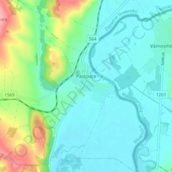
Name: Pastovce topographic map, elevation, terrain.
Average elevation: 135 m
Minimum elevation: 108 m
Maximum elevation: 226 m
The village lies at an altitude of 124 metres and covers an area of 12.859 km². It has a population of about 540 people.
Other topographic maps
Click on a map to view its topography, its elevation and its terrain.
Tlmače
Slovakia > Region of Nitra > District of Levice
Tlmače, District of Levice, Region of Nitra, Western Slovakia, 935 21, Slovakia
Average elevation: 192 m
Veselá
Slovakia > Region of Nitra > District of Levice > Šarovce
Veselá, Šarovce, District of Levice, Region of Nitra, Western Slovakia, Slovakia
Average elevation: 149 m
Šahy
Slovakia > Region of Nitra > District of Levice
Šahy, District of Levice, Region of Nitra, Western Slovakia, 936 01, Slovakia
Average elevation: 179 m