
East Tennessee topographic map
Interactive map
Click on the map to display elevation.
About this map
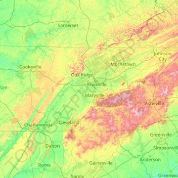
Name: East Tennessee topographic map, elevation, terrain.
Location: East Tennessee, Tennessee, United States (34.98294 -85.87303 36.61621 -81.64722)
Average elevation: 435 m
Minimum elevation: 123 m
Maximum elevation: 1,983 m
Other topographic maps
Click on a map to view its topography, its elevation and its terrain.
Knoxville
United States > Tennessee > Knox County
According to the United States Census Bureau, the city has a total area of 104.2 square miles (269.8 km2), of which 98.5 square miles (255.2 km2) is land and 5.6 square miles (14.6 km2), or 5.42%, is water. Elevations range from just over 800 feet (240 m) along the riverfront to just over 1,000 feet (300 m) on…
Average elevation: 307 m
Cookeville
United States > Tennessee > Putnam County
Located on the Highland Rim, Cookeville's elevation (1100 ft AMSL) is a few hundred feet higher than either Nashville or Knoxville. As a result, temperatures and humidity levels are generally slightly lower in Cookeville than in either the Nashville Basin or in the Tennessee Valley.
Average elevation: 332 m
Great Smoky Mountains National Park
United States > Tennessee > Sevier County
Elevations in the park range from about 875 feet (267 m) to 6,643 feet (2,025 m) at the summit of Clingmans Dome. Within the park a total of sixteen mountains reach higher than 5,000 feet (1,520 m).
Average elevation: 765 m
Chattanooga
United States > Tennessee > Hamilton County
According to the United States Census Bureau, the city has a total area of 144.6 square miles (374.4 km2), of which 137.1 square miles (355.2 km2) are land and 7.4 square miles (19.2 km2), or 5.12%, are water. The most prominent natural features in and around Chattanooga are the Tennessee River and the…
Average elevation: 331 m
Nashville-Davidson
United States > Tennessee > Davidson County
Nashville lies on the Cumberland River in the northwestern portion of the Nashville Basin. Nashville's elevation ranges from its lowest point, 385 feet (117 m) above sea level at the Cumberland River, to its highest point, 1,163 feet (354 m) above sea level in the Radnor Lake State Natural Area. Nashville also…
Average elevation: 184 m
Roan Mountain
United States > Tennessee > Carter County
Roan Mountain is located in northeast Tennessee at 36°11′39″N 82°4′6″W / 36.19417°N 82.06833°W / 36.19417; -82.06833 (36.194219, -82.068417). According to the United States Census Bureau, the CDP has a total area of 6.6 square miles (17.2 km2), all land. The elevation of Roan Mountain near…
Average elevation: 926 m
Carrington Hills Pond
United States > Tennessee > Williamson County > Franklin
Average elevation: 224 m
Country Club Estates
United States > Tennessee > Williamson County > Brentwood
Average elevation: 217 m
Wilder Point
United States > Tennessee > Hamilton County > Signal Mountain > Palisades
Average elevation: 409 m
French Broad River
The French Broad River is believed to be one of the oldest in the world, cutting over eons through ancient rocks in the Southern Appalachian Mountains. The French Broad predates the Alleghanian orogeny, through the resulting mountains it cuts; however, the current topographic relief of the Southern…
Average elevation: 803 m
Cherokee Dam
United States > Tennessee > Jefferson County
Cherokee Dam is a gravity-type concrete spillway dam consisting of nine crest gates and eight sluice gates (the latter allowing reservoir control when water level is low). The combined capacity of the dam's four hydroelectric generators is 135,200 kilowatts. Cherokee Lake has a flood-storage capacity of…
Average elevation: 317 m
Altamont
United States > Tennessee > Grundy County
Altamont was established in 1848 as a county seat for Grundy County, which had been created in 1844. General Adrian Northcutt, a prominent local farmer and military officer, was the prime advocate for the site's selection. The town's name comes from combining alto (meaning "altitude") and mont (meaning…
Average elevation: 565 m
New Tazewell
United States > Tennessee > Claiborne County
When the railroad line was built from Knoxville through Cumberland Gap in the late 1880s, it bypassed the city of Tazewell. It is uncertain whether the railroad was unable to obtain right of way, or whether the decision was made because of topography, but the railroad depot was built about two miles to the…
Average elevation: 465 m
Grassland Addition
United States > Tennessee > Cumberland County > Crossville
Average elevation: 560 m
Tullahoma
United States > Tennessee > Coffee County
Tullahoma is located in the southwest corner of Coffee County at 35°22′7″N 86°12′48″W / 35.36861°N 86.21333°W / 35.36861; -86.21333 (35.368511, -86.213258), and extends south into Franklin County. It is situated at the edge of the Highland Rim, with flatter topography than in the…
Average elevation: 323 m