
Make a donation
Gear up for your next adventure:
As an Amazon Associate, this site earns from qualifying purchases at no extra cost to you.
Bingham topographic map
Click on the map to display elevation.
Make a donation
Gear up for your next adventure:
As an Amazon Associate, this site earns from qualifying purchases at no extra cost to you.
About this map
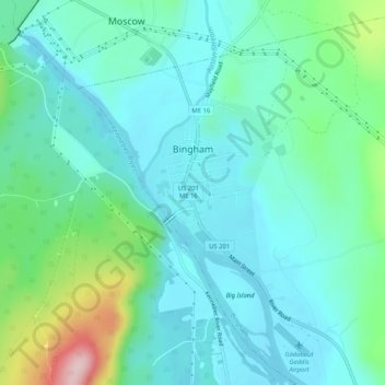
Name: Bingham topographic map, elevation, terrain.
Location: Bingham, Somerset County, Maine, United States (44.97757 -69.89808 45.08286 -69.75037)
Average elevation: 205 m
Minimum elevation: 89 m
Maximum elevation: 511 m
Make a donation
Gear up for your next adventure:
As an Amazon Associate, this site earns from qualifying purchases at no extra cost to you.
Other topographic maps
Click on a map to view its topography, its elevation and its terrain.
No Name Pond
United States > Maine > Somerset County > Bald Mountain Township T4 R3
Average elevation: 686 m
Make a donation
Gear up for your next adventure:
As an Amazon Associate, this site earns from qualifying purchases at no extra cost to you.