
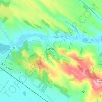
Šarkan topographic map
Interactive map
Click on the map to display elevation.
About this map
Name: Šarkan topographic map, elevation, terrain.
Average elevation: 159 m
Minimum elevation: 118 m
Maximum elevation: 247 m
Other topographic maps
Click on a map to view its topography, its elevation and its terrain.
Veľký Kýr
Slovakia > Region of Nitra > District of Nové Zámky
Veľký Kýr, District of Nové Zámky, Region of Nitra, Western Slovakia, 941 07, Slovakia
Average elevation: 135 m
Bíňa
Slovakia > Region of Nitra > District of Nové Zámky
Bíňa, District of Nové Zámky, Region of Nitra, Western Slovakia, 943 56, Slovakia
Average elevation: 137 m
Kolta
Slovakia > Region of Nitra > District of Nové Zámky
Kolta, District of Nové Zámky, Region of Nitra, Western Slovakia, 941 33, Slovakia
Average elevation: 204 m