Geolocate

Marcross topographic map

Click on the map to display elevation.

About this map

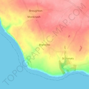
Name: Marcross topographic map, elevation, terrain.

Location: Marcross, Vale of Glamorgan, Wales, CF61 1ZG, United Kingdom (51.39208 -3.56733 51.43208 -3.52733)

Average elevation: 47 m

Minimum elevation: 0 m

Maximum elevation: 95 m

Vale of Glamorgan trails, hiking, mountain biking, running and outdoor activities

Other topographic maps

Click on a map to view its topography, its elevation and its terrain.

Barry

United Kingdom > Wales > Vale of Glamorgan

Average elevation: 29 m

Penarth

United Kingdom > Wales > Vale of Glamorgan

Average elevation: 17 m

Dinas Powys

United Kingdom > Wales > Vale of Glamorgan

Average elevation: 30 m

St. Athan

United Kingdom > Wales > Vale of Glamorgan > St Athan

Average elevation: 30 m

Romilly Park

United Kingdom > Wales > Vale of Glamorgan > Barry

Average elevation: 26 m

Barry

United Kingdom > Wales > Vale of Glamorgan

Average elevation: 29 m

Barry

United Kingdom > Wales > Vale of Glamorgan

Average elevation: 29 m

Barry

United Kingdom > Wales > Vale of Glamorgan

Average elevation: 29 m

Gear up for your next adventure:

🗺️Topographic Maps - Detailed maps showing elevation and terrain features
📸Action Camera Chest Mounts - Record your ascent following topographic paths hands-free
🛌Insulated Sleeping Mats - Crucial thermal protection when sleeping on cold, uneven ground
🧤Waterproof Overmitts - Extreme weather protection for hikers and mountaineers
👟Men's Trail Running Shoes - Lightweight grip for fast movement over topographic contours

As an Amazon Associate, this site earns from qualifying purchases at no extra cost to you.