Geolocate

Bucharest topographic map

Click on the map to display elevation.

About this map

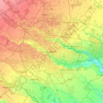
Name: Bucharest topographic map, elevation, terrain.

Location: Bucharest, Sector 1, Bucharest, 010051, Romania (44.27614 25.94272 44.59614 26.26272)

Average elevation: 82 m

Minimum elevation: 47 m

Maximum elevation: 115 m

Gear up for your next adventure:

🔋Power Banks - Portable chargers for long outdoor trips
🗺️Ordnance Survey Maps - Official UK maps for walking and outdoor activities
🎒Hiking Daypacks (20L) - Compact backpacks for day trips and technical mountain ascents
🧣Neck Gaiters - Protects against wind and sun on exposed ridges and peaks
🥤Collapsible Water Bottles - Save space in your rucksack as you consume your water

As an Amazon Associate, this site earns from qualifying purchases at no extra cost to you.