
Thank you for supporting this site ❤️
Make a donation
Make a donation
Gear up for your next adventure:
As an Amazon Associate, this site earns from qualifying purchases at no extra cost to you.
Envigado topographic map
Click on the map to display elevation.
Thank you for supporting this site ❤️
Make a donation
Make a donation
Gear up for your next adventure:
As an Amazon Associate, this site earns from qualifying purchases at no extra cost to you.
About this map
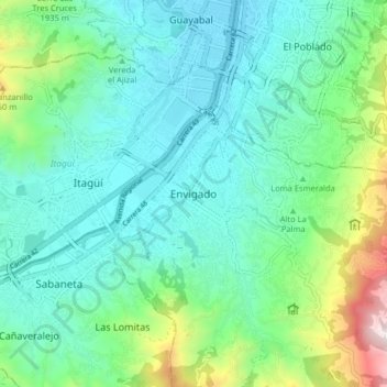
Name: Envigado topographic map, elevation, terrain.
Location: Envigado, Valle de Aburrá, Antioquia, 055421, Colombia (6.13013 -75.62742 6.21013 -75.54742)
Average elevation: 1,747 m
Minimum elevation: 1,493 m
Maximum elevation: 2,635 m
Thank you for supporting this site ❤️
Make a donation
Make a donation
Gear up for your next adventure:
As an Amazon Associate, this site earns from qualifying purchases at no extra cost to you.