
Thank you for supporting this site ❤️
Make a donation
Make a donation
Gear up for your next adventure:
As an Amazon Associate, this site earns from qualifying purchases at no extra cost to you.
Canale topographic map
Click on the map to display elevation.
Thank you for supporting this site ❤️
Make a donation
Make a donation
Gear up for your next adventure:
As an Amazon Associate, this site earns from qualifying purchases at no extra cost to you.
Canale
Canale è una frazione del comune di Fontanigorda. È situato a circa 780 m di altitudine sulla sponda destra del fiume Trebbia.
Thank you for supporting this site ❤️
Make a donation
Make a donation
Gear up for your next adventure:
As an Amazon Associate, this site earns from qualifying purchases at no extra cost to you.
About this map
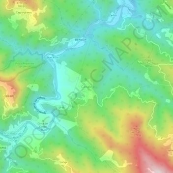
Name: Canale topographic map, elevation, terrain.
Location: Canale, Fontanigorda, Genova, Liguria, 16023, Italia (44.51651 9.25117 44.55651 9.29117)
Average elevation: 790 m
Minimum elevation: 586 m
Maximum elevation: 1,216 m
Thank you for supporting this site ❤️
Make a donation
Make a donation
Gear up for your next adventure:
As an Amazon Associate, this site earns from qualifying purchases at no extra cost to you.