Geolocate

Chengdu topographic map

Click on the map to display elevation.

Chengdu

The vast plain on which Chengdu is located has an elevation ranging from 450 to 720 metres (1,480 to 2,360 feet).

About this map

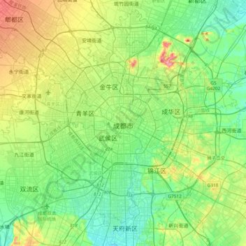
Name: Chengdu topographic map, elevation, terrain.

Location: Chengdu, Qingyang District, Chengdu City, Sichuan, 610015, China (30.50242 103.90332 30.82242 104.22332)

Average elevation: 505 m

Minimum elevation: 469 m

Maximum elevation: 590 m

Other topographic maps

Click on a map to view its topography, its elevation and its terrain.

Jinjiang District

China > Sichuan > Chengdu

Average elevation: 498 m

Jintang County

China > Sichuan > Chengdu

Average elevation: 495 m

Wuhou District

China > Sichuan > Chengdu

The terrain of Wuhou District is flat, sloping from northwest to southeast, with an average altitude of 502.5 meters. The plains within the territory are composed of flood plains, alluvial fans, fan plains and other plains. The geological structure of the entire region is mainly Quaternary loose accumulations.

Average elevation: 492 m

Chenghua District

China > Sichuan > Chengdu

Average elevation: 504 m

Jinniu District

China > Sichuan > Chengdu

Average elevation: 512 m

Pengzhou

China > Sichuan > Chengdu

Average elevation: 1,161 m

Jinjiang District

China > Sichuan > Chengdu

Average elevation: 498 m

Gear up for your next adventure:

🚲Bikepacking Frame Bags - Storage for tools and navigation gear on long off-road rides
👕Technical Hiking Tees - Moisture-management for high-exertion climbs
🔥Emergency Fire Starters - Reliable ignition tools for survival situations in damp conditions
🧰First Aid Kits - Essential safety kits for outdoor activities
🪓Outdoor Multitools - Versatile tools for hiking and camping

As an Amazon Associate, this site earns from qualifying purchases at no extra cost to you.