
Vila-Roja topographic map
Interactive map
Click on the map to display elevation.
About this map
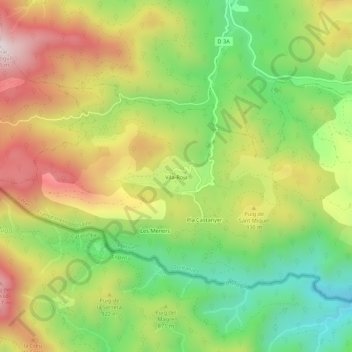
Name: Vila-Roja topographic map, elevation, terrain.
Average elevation: 830 m
Minimum elevation: 495 m
Maximum elevation: 1,228 m
Other topographic maps
Click on a map to view its topography, its elevation and its terrain.
Pla Castanyer
France > Occitanie > Pyrénées-Orientales > Coustouges
Pla Castanyer, Coustouges, Céret, Pyrénées-Orientales, Occitanie, France métropolitaine, 66260, France
Average elevation: 805 m
Les Escomes
France > Occitanie > Pyrénées-Orientales > Coustouges
Les Escomes, Coustouges, Céret, Pyrénées-Orientales, Occitanie, France métropolitaine, 66260, France
Average elevation: 741 m