
Covington topographic map
Interactive map
Click on the map to display elevation.
About this map
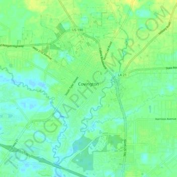
Name: Covington topographic map, elevation, terrain.
Location: Covington, St. Tammany Parish, Louisiana, United States (30.43985 -90.17145 30.50666 -90.08112)
Average elevation: 9 m
Minimum elevation: 1 m
Maximum elevation: 19 m
Other topographic maps
Click on a map to view its topography, its elevation and its terrain.
North Shore
United States > Louisiana > St. Tammany Parish
North Shore, St. Tammany Parish, Louisiana, United States
Average elevation: 0 m
Bayou Des Mats
United States > Louisiana > St. Tammany Parish > Lacombe
Bayou Des Mats, Lacombe, St. Tammany Parish, Louisiana, United States
Average elevation: 2 m
Pearl River
United States > Louisiana > St. Tammany Parish
Pearl River, St. Tammany Parish, Louisiana, United States
Average elevation: 19 m
Noth Forest
United States > Louisiana > St. Tammany Parish
Noth Forest, St. Tammany Parish, Louisiana, 70459, United States
Average elevation: 9 m
Abita Springs
United States > Louisiana > St. Tammany Parish
Abita Springs, St. Tammany Parish, Louisiana, 70420, United States
Average elevation: 10 m
Forest Pines
United States > Louisiana > St. Tammany Parish > Slidell
Forest Pines, Slidell, St. Tammany Parish, Louisiana, 70460, United States
Average elevation: 6 m
Lake Pontchartrain
United States > Louisiana > St. Tammany Parish
Lake Pontchartrain, St. Tammany Parish, Louisiana, United States
Average elevation: 3 m
Saint Tammany
United States > Louisiana > St. Tammany Parish
Saint Tammany, St. Tammany Parish, Louisiana, United States
Average elevation: 9 m
Slidell
United States > Louisiana > St. Tammany Parish
Slidell, St. Tammany Parish, Louisiana, 70458, United States
Average elevation: 6 m
Mandeville
United States > Louisiana > St. Tammany Parish
Mandeville, St. Tammany Parish, Louisiana, United States
Average elevation: 6 m