
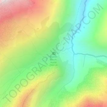
Martin-Busch-Hütte topographic map
Interactive map
Click on the map to display elevation.
About this map
Name: Martin-Busch-Hütte topographic map, elevation, terrain.
Average elevation: 2,681 m
Minimum elevation: 2,227 m
Maximum elevation: 3,346 m
Other topographic maps
Click on a map to view its topography, its elevation and its terrain.
Wildspitze
Autriche > Tyrol > Bezirk Imst > Gemeinde Sölden
Wildspitze, Gemeinde Sölden, Bezirk Imst, Tyrol, 6458, Autriche
Average elevation: 3,284 m
Zuckerhütl
Autriche > Tyrol > Bezirk Imst > Gemeinde Sölden
Zuckerhütl, Gemeinde Sölden, Bezirk Imst, Tyrol, Autriche
Average elevation: 3,106 m
Hochjoch-Hospiz
Autriche > Tyrol > Bezirk Imst > Gemeinde Sölden
Hochjoch-Hospiz, 404, Cyprian-Granbichler-Weg, Gemeinde Sölden, Bezirk Imst, Tyrol, 6458, Autriche
Average elevation: 2,596 m
Vernagthütte
Autriche > Tyrol > Bezirk Imst > Gemeinde Sölden
Vernagthütte, 402, Hütten Vent, Gemeinde Sölden, Bezirk Imst, Tyrol, 6458, Autriche
Average elevation: 2,849 m