
Provincia de Valparaíso topographic map
Interactive map
Click on the map to display elevation.
About this map
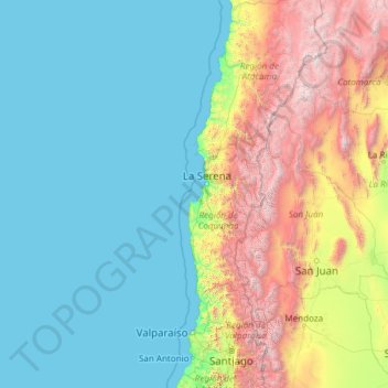
Name: Provincia de Valparaíso topographic map, elevation, terrain.
Location: Provincia de Valparaíso, Chile (-33.81631 -80.83776 -26.28623 -71.19555)
Average elevation: 984 m
Minimum elevation: 0 m
Maximum elevation: 6,768 m
Other topographic maps
Click on a map to view its topography, its elevation and its terrain.
San Esteban
Chile > Región de Valparaíso > San Esteban
San Esteban, Provincia de Los Andes, Región de Valparaíso, 2120000, Chile
Average elevation: 1,732 m
Ojos de Agua
Chile > Región de Valparaíso > Los Andes
Ojos de Agua, Los Andes, Provincia de Los Andes, Región de Valparaíso, Chile
Average elevation: 3,326 m