Geolocate

Elgin topographic map

Click on the map to display elevation.

About this map

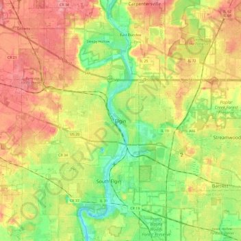
Name: Elgin topographic map, elevation, terrain.

Location: Elgin, Elgin Township, Kane County, Illinois, United States (41.97137 -88.45457 42.10358 -88.22277)

Average elevation: 250 m

Minimum elevation: 209 m

Maximum elevation: 291 m

Other topographic maps

Click on a map to view its topography, its elevation and its terrain.

Campton Township

United States > Illinois > Kane County

Average elevation: 267 m

Aurora

United States > Illinois > Kane County > Aurora

Average elevation: 216 m

Gear up for your next adventure:

🧣Neck Gaiters - Protects against wind and sun on exposed ridges and peaks
🧤Hiking Gloves - Warm and durable gloves for cold-weather walks
🎒Multi-day Trekking Packs - Large capacity backpacks for wild camping and long-distance trails
🔦Outdoor Torches - Reliable torches for night navigation
🥫Expedition Meals - Lightweight, high-calorie nutrition for long-distance hikers

As an Amazon Associate, this site earns from qualifying purchases at no extra cost to you.