
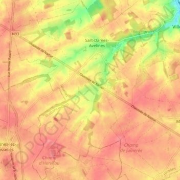
Sart-Dames-Avelines topographic map
Interactive map
Click on the map to display elevation.
About this map
Name: Sart-Dames-Avelines topographic map, elevation, terrain.
Average elevation: 146 m
Minimum elevation: 98 m
Maximum elevation: 167 m
Other topographic maps
Click on a map to view its topography, its elevation and its terrain.
Marbais
Belgique > Brabant wallon > Nivelles > Villers-la-Ville
Marbais, Villers-la-Ville, Nivelles, Brabant wallon, Wallonie, Belgique
Average elevation: 147 m
Tilly
Belgique > Brabant wallon > Nivelles > Villers-la-Ville
Tilly, Villers-la-Ville, Nivelles, Brabant wallon, Wallonie, 1495, Belgique
Average elevation: 141 m
Mellery
Belgique > Brabant wallon > Nivelles > Villers-la-Ville
Mellery, Villers-la-Ville, Nivelles, Brabant wallon, Wallonie, 1495, Belgique
Average elevation: 143 m