
La Gilberdière topographic map
Interactive map
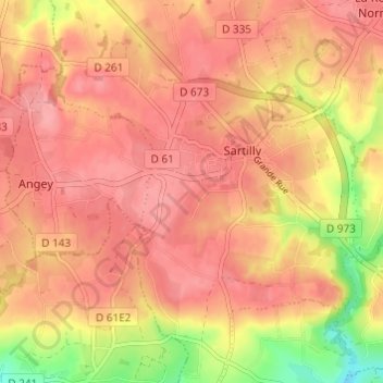
Click on the map to display elevation.
About this map
Name: La Gilberdière topographic map, elevation, terrain.
Average elevation: 92 m
Minimum elevation: 26 m
Maximum elevation: 121 m
Other topographic maps
Click on a map to view its topography, its elevation and its terrain.
Champcey
France > Normandie > Manche > Sartilly-Baie-Bocage
Champcey, Sartilly-Baie-Bocage, Avranches, Manche, Normandie, France métropolitaine, 50530, France
Average elevation: 53 m
La Rochelle-Normande
France > Normandie > Manche > Sartilly-Baie-Bocage
La Rochelle-Normande, Sartilly-Baie-Bocage, Avranches, Manche, Normandie, France métropolitaine, 50530, France
Average elevation: 97 m
Angey
France > Normandie > Manche > Sartilly-Baie-Bocage
Angey, Sartilly-Baie-Bocage, Avranches, Manche, Normandie, France métropolitaine, 50530, France
Average elevation: 103 m
Le Manoir
France > Normandie > Manche > Sartilly-Baie-Bocage
Le Manoir, Sartilly, Sartilly-Baie-Bocage, Avranches, Manche, Normandie, France métropolitaine, 50530, France
Average elevation: 96 m
L'Anquetillière
France > Normandie > Manche > Sartilly-Baie-Bocage
L'Anquetillière, La Rochelle-Normande, Sartilly-Baie-Bocage, Avranches, Manche, Normandie, France métropolitaine, 50530, France
Average elevation: 103 m
Sartilly
France > Normandie > Manche > Sartilly-Baie-Bocage
Sartilly, Sartilly-Baie-Bocage, Avranches, Manche, Normandie, France métropolitaine, 50530, France
Average elevation: 89 m