
Rechnitz topographic map
Interactive map
Click on the map to display elevation.
About this map
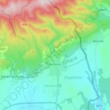
Name: Rechnitz topographic map, elevation, terrain.
Location: Rechnitz, Bezirk Oberwart, Burgenland, 7471, Austria (47.27086 16.38423 47.35292 16.48942)
Average elevation: 423 m
Minimum elevation: 258 m
Maximum elevation: 874 m
Other topographic maps
Click on a map to view its topography, its elevation and its terrain.
Unterwaldbauern
Austria > Burgenland > Bezirk Oberwart > Grafenschachen
Unterwaldbauern, Grafenschachen, Bezirk Oberwart, Burgenland, 7243, Austria
Average elevation: 450 m