
Mauerkirchen topographic map
Interactive map
Click on the map to display elevation.
About this map
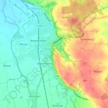
Name: Mauerkirchen topographic map, elevation, terrain.
Average elevation: 420 m
Minimum elevation: 392 m
Maximum elevation: 458 m
Other topographic maps
Click on a map to view its topography, its elevation and its terrain.
Schneegattern
Austria > Upper Austria > Bezirk Braunau am Inn > Schneegattern
Schneegattern, Lengau, Bezirk Braunau am Inn, Upper Austria, 5211, Austria
Average elevation: 593 m