
Bad Tölz topographic map
Interactive map
Click on the map to display elevation.
About this map
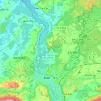
Name: Bad Tölz topographic map, elevation, terrain.
Average elevation: 688 m
Minimum elevation: 608 m
Maximum elevation: 958 m
Other topographic maps
Click on a map to view its topography, its elevation and its terrain.
Lenggries
Duitsland > Beieren > Landkreis Bad Tölz-Wolfratshausen
Lenggries, Landkreis Bad Tölz-Wolfratshausen, Beieren, 83661, Duitsland
Average elevation: 1,096 m
Wegscheid
Duitsland > Beieren > Landkreis Bad Tölz-Wolfratshausen > Lenggries
Wegscheid, Lenggries, Landkreis Bad Tölz-Wolfratshausen, Beieren, 83661, Duitsland
Average elevation: 750 m