
Make a donation
Gear up for your next adventure:
As an Amazon Associate, this site earns from qualifying purchases at no extra cost to you.
Cidade de Chimoio topographic map
Click on the map to display elevation.
Make a donation
Gear up for your next adventure:
As an Amazon Associate, this site earns from qualifying purchases at no extra cost to you.
Cidade de Chimoio
The city of Chimoio, capital of Manica Province, lies on the Beira Corridor at an altitude of 750 metres, linking the coast and the interior of the continent. The name Chimoio comes from one of the sons of Ganda, paramount chief of the totemic Moyo clan, who came from M´bire and settled in those lands. Oral history says Chimoio, who was a great hunter, once killed an elephant in the lands of another clan. Chaurumba, their chief, judged Chimoio's behaviour to be a crime and ordered his immediate execution. Paramount Chief Ganda then requested permission for his son to be buried in Chaurumba's land and for one of his relatives to settle close to the grave in order to tend and watch over it. From then on, all descendants of the guardians of Chimoio's tomb, together with the site of the tomb, came to be called Chimoio (which in the local dialect, citewe, means “Great heart”). The strategic position of that region made it a privileged centre through which products passed from the hinterland to the coast.
Make a donation
Gear up for your next adventure:
As an Amazon Associate, this site earns from qualifying purchases at no extra cost to you.
About this map
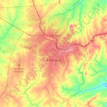
Name: Cidade de Chimoio topographic map, elevation, terrain.
Location: Cidade de Chimoio, Manica Province, 2200, Mozambique (-19.20208 33.37457 -19.06740 33.52624)
Average elevation: 661 m
Minimum elevation: 544 m
Maximum elevation: 772 m
Make a donation
Gear up for your next adventure:
As an Amazon Associate, this site earns from qualifying purchases at no extra cost to you.
Other topographic maps
Click on a map to view its topography, its elevation and its terrain.
Make a donation
Gear up for your next adventure:
As an Amazon Associate, this site earns from qualifying purchases at no extra cost to you.