
Acorn topographic map
Interactive map
Click on the map to display elevation.
About this map
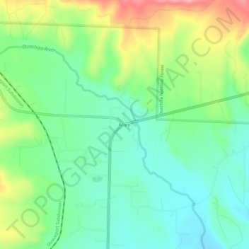
Name: Acorn topographic map, elevation, terrain.
Location: Acorn, Polk County, Arkansas, United States (34.62288 -94.22104 34.66288 -94.18104)
Average elevation: 351 m
Minimum elevation: 308 m
Maximum elevation: 433 m
Other topographic maps
Click on a map to view its topography, its elevation and its terrain.
Big Fork
United States > Arkansas > Polk County
Big Fork, Polk County, Arkansas, United States
Average elevation: 353 m
Mena
United States > Arkansas > Polk County
Mena, Polk County, Arkansas, 72953, United States
Average elevation: 355 m
Ouachita River
United States > Arkansas > Polk County > Rich Mountain
Ouachita River, Rich Mountain, Polk County, Arkansas, United States
Average elevation: 578 m