
Tortuguero National Park topographic map
Interactive map
Click on the map to display elevation.
About this map
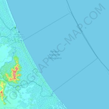
Name: Tortuguero National Park topographic map, elevation, terrain.
Average elevation: 5 m
Minimum elevation: -2 m
Maximum elevation: 286 m
The park is located on the Caribbean coast of Costa Rica and covers an area of 77,032 acres (31,174 ha). It is bounded with an elevation range of 0–230 metres (0–755 ft), indicative of a sea coastal region to low hilly topography. The Tortuguero National Park has over 20 miles of coastline, which provides sea turtles a protected place to lay their eggs. Tortuguero is bordered on the north by the Barra del Colorado Wildlife Refuge (with habitats and climate similar to Tortuguero), to the south by the mouth of the Parismina River and the Cariari National Wetlands, the town of Tortuguero at the mouth of the Tortuguero River, and the Dr. Archie Carr Wildlife Refuge, which is a biological station to carry out turtle tagging program run by the Caribbean Conservation Corporation (Now known as the Sea Turtle Conservancy).
Other topographic maps
Click on a map to view its topography, its elevation and its terrain.
Puerto Lindo
Costa Rica > Cantón Pococí > Colorado
Puerto Lindo, Colorado, Cantón Pococí, Limón Province, 70206, Costa Rica
Average elevation: 10 m
Condado del Río
Costa Rica > Cantón Pococí > Jiménez
Condado del Río, Jiménez, Cantón Pococí, Limón Province, 70202, Costa Rica
Average elevation: 372 m
Cariari
Cariari, Cantón Pococí, Limón Province, 70205, Costa Rica
Average elevation: 41 m
Río Jiménez
Costa Rica > Cantón Pococí > Guácimo > Jiménez
Río Jiménez, Guácimo, Jiménez, Cantón Pococí, Limón Province, 70202, Costa Rica
Average elevation: 382 m