
Make a donation
Gear up for your next adventure:
As an Amazon Associate, this site earns from qualifying purchases at no extra cost to you.
Middletown topographic map
Click on the map to display elevation.
Make a donation
Gear up for your next adventure:
As an Amazon Associate, this site earns from qualifying purchases at no extra cost to you.
Middletown
Middletown has an elevation of 1,099 feet (335 m). According to the United States Census Bureau, the CDP has a total area of 1.8 square miles (4.7 km2), all of it land.
Make a donation
Gear up for your next adventure:
As an Amazon Associate, this site earns from qualifying purchases at no extra cost to you.
About this map
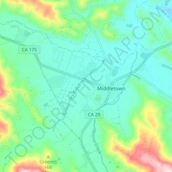
Name: Middletown topographic map, elevation, terrain.
Location: Middletown, Lake County, California, United States (38.73365 -122.66462 38.77236 -122.60096)
Average elevation: 377 m
Minimum elevation: 311 m
Maximum elevation: 583 m
Make a donation
Gear up for your next adventure:
As an Amazon Associate, this site earns from qualifying purchases at no extra cost to you.