Geolocate

Tuerong topographic map

Interactive map

Click on the map to display elevation.

About this map

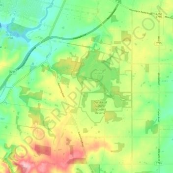
Name: Tuerong topographic map, elevation, terrain.

Location: Tuerong, Shire of Mornington Peninsula, Victoria, Australia (-38.32409 145.02663 -38.26985 145.14566)

Average elevation: 76 m

Minimum elevation: 8 m

Maximum elevation: 177 m

Other topographic maps

Click on a map to view its topography, its elevation and its terrain.

Melbourne

Australia > Victoria > Melbourne

Melbourne, City of Melbourne, Victoria, Australia

Average elevation: 185 m

Pura Pura

Australia > Victoria > Pura Pura

Pura Pura, Shire of Moyne, Barwon South West, Victoria, Australia

Average elevation: 211 m

Geelong

Australia > Victoria > Geelong

Geelong, City of Greater Geelong, Barwon South West, Victoria, VIC 3220, Australia

Average elevation: 42 m

Buxton

Australia > Victoria > Buxton

Buxton, Shire of Murrindindi, Hume, Victoria, 3711, Australia

Average elevation: 318 m

Manifold Heights

Australia > Victoria > Geelong

Manifold Heights, Geelong, City of Greater Geelong, Barwon South West, Victoria, 3218, Australia

Average elevation: 41 m

Avalon

Australia > Victoria > Geelong

Avalon, Geelong, City of Greater Geelong, Barwon South West, Victoria, 3212, Australia

Average elevation: 9 m