Geolocate

Ubbena topographic map

Click on the map to display elevation.

About this map

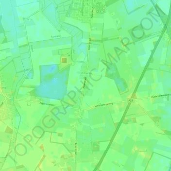
Name: Ubbena topographic map, elevation, terrain.

Location: Ubbena, Assen, Drenthe, Nederland (53.03769 6.55000 53.06192 6.60810)

Average elevation: 10 m

Minimum elevation: 2 m

Maximum elevation: 16 m

Other topographic maps

Click on a map to view its topography, its elevation and its terrain.

Witten

Nederland > Drenthe > Assen

Average elevation: 14 m

Schieven

Nederland > Drenthe > Assen

Average elevation: 13 m

Asserbos

Nederland > Drenthe > Assen

Average elevation: 13 m

Gear up for your next adventure:

🧥Breathable Waterproof Jackets - Essential rain protection for the unpredictable British climate
🛰️Outdoor GPS Navigation - Navigation devices for remote and off-grid areas
🔋Solar Chargers - Eco-friendly charging solutions for outdoor use
🥾Hiking Boot Waterproofing Wax - Maintain the lifespan of your leather trekking boots
🚶Walking Pedometers - Simple distance tracking for casual trail walkers

As an Amazon Associate, this site earns from qualifying purchases at no extra cost to you.