
Make a donation
Gear up for your next adventure:
As an Amazon Associate, this site earns from qualifying purchases at no extra cost to you.
Boones Mill topographic map
Click on the map to display elevation.
Make a donation
Gear up for your next adventure:
As an Amazon Associate, this site earns from qualifying purchases at no extra cost to you.
Boones Mill
According to the United States Census Bureau, the town has a total area of 0.73 square miles (1.9 km2), all of it land. The town is in the valley of Maggodee Creek, a southeast-flowing tributary of the Blackwater River, part of the Roanoke River watershed. Murray Knob, elevation 2,286 feet (697 m), rises 2 miles (3 km) to the north on the crest of the Blue Ridge, and the eastern end of Cahas Mountain, at 2,992 feet (912 m), is 2 miles to the west.
Make a donation
Gear up for your next adventure:
As an Amazon Associate, this site earns from qualifying purchases at no extra cost to you.
About this map
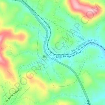
Name: Boones Mill topographic map, elevation, terrain.
Location: Boones Mill, Franklin County, Virginia, United States (37.10687 -79.95893 37.12478 -79.94342)
Average elevation: 390 m
Minimum elevation: 326 m
Maximum elevation: 506 m
Make a donation
Gear up for your next adventure:
As an Amazon Associate, this site earns from qualifying purchases at no extra cost to you.
Other topographic maps
Click on a map to view its topography, its elevation and its terrain.
Make a donation
Gear up for your next adventure:
As an Amazon Associate, this site earns from qualifying purchases at no extra cost to you.