
Thank you for supporting this site ❤️
Make a donation
Make a donation
Gear up for your next adventure:
As an Amazon Associate, this site earns from qualifying purchases at no extra cost to you.
Aragosa topographic map
Click on the map to display elevation.
Thank you for supporting this site ❤️
Make a donation
Make a donation
Gear up for your next adventure:
As an Amazon Associate, this site earns from qualifying purchases at no extra cost to you.
About this map
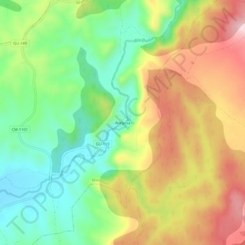
Name: Aragosa topographic map, elevation, terrain.
Location: Aragosa, Mandayona, Guadalajara, Castile-La Mancha, Spain (40.95055 -2.73195 40.99055 -2.69195)
Average elevation: 1,003 m
Minimum elevation: 871 m
Maximum elevation: 1,170 m
Thank you for supporting this site ❤️
Make a donation
Make a donation
Gear up for your next adventure:
As an Amazon Associate, this site earns from qualifying purchases at no extra cost to you.