
Make a donation
Gear up for your next adventure:
As an Amazon Associate, this site earns from qualifying purchases at no extra cost to you.
Paita topographic map
Click on the map to display elevation.
Make a donation
Gear up for your next adventure:
As an Amazon Associate, this site earns from qualifying purchases at no extra cost to you.
Paita
Al sur de la ciudad se encuentra un conjunto de elevaciones que destacan no solo por su altitudes poco usuales en el norte del Perú, sino también por su interés legendario-histórico, geológico y mineralógico. Este conjunto de elevaciones se le conoce como La Silla de Paita o Cerro Azul (debido a la tonalidad azul que presenta de lejos).
Make a donation
Gear up for your next adventure:
As an Amazon Associate, this site earns from qualifying purchases at no extra cost to you.
About this map
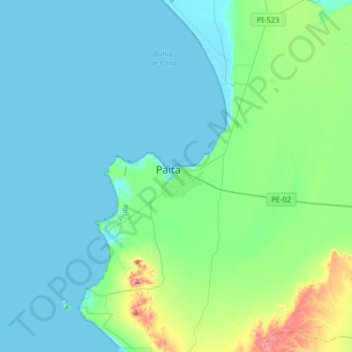
Name: Paita topographic map, elevation, terrain.
Location: Paita, Provincia de Paita, Piura, 20701, Perú (-5.24516 -81.27368 -4.92516 -80.95368)
Average elevation: 51 m
Minimum elevation: -2 m
Maximum elevation: 359 m
Make a donation
Gear up for your next adventure:
As an Amazon Associate, this site earns from qualifying purchases at no extra cost to you.
Other topographic maps
Click on a map to view its topography, its elevation and its terrain.