
منشاه العمارى topographic map
Interactive map
Click on the map to display elevation.
About this map
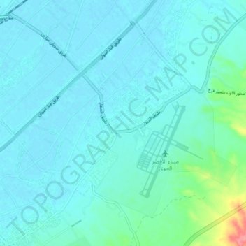
Name: منشاه العمارى topographic map, elevation, terrain.
Location: منشاه العمارى, Luxor (gouvernement), 85841, Egypte (25.64551 32.65566 25.71250 32.73133)
Average elevation: 86 m
Minimum elevation: 76 m
Maximum elevation: 153 m
Other topographic maps
Click on a map to view its topography, its elevation and its terrain.
مدينه القرنة الجديدة
مدينه القرنة الجديدة, Luxor (gouvernement), 85831, Egypte
Average elevation: 123 m
الكرنك القديم
الكرنك القديم, Luxor (gouvernement), 81693, Egypte
Average elevation: 78 m
Luxor
Luxor, Luxor (gouvernement), 85951, Egypte
Average elevation: 158 m