Geolocate

Mambo topographic map

Interactive map

Click on the map to display elevation.

About this map

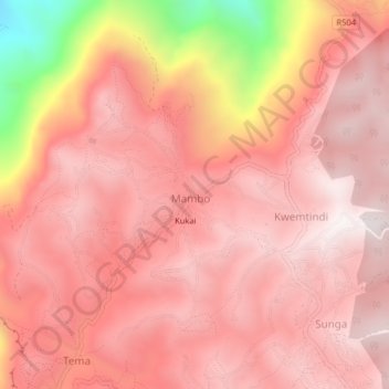
Name: Mambo topographic map, elevation, terrain.

Location: Mambo, Lushoto, Tanga, Northern Zone, Tanzania (-4.53271 38.20568 -4.49271 38.24568)

Average elevation: 1,721 m

Minimum elevation: 911 m

Maximum elevation: 1,993 m

Other topographic maps

Click on a map to view its topography, its elevation and its terrain.

Lushoto

Tanzania > Tanga

Lushoto, Tanga, Northern Zone, Tanzania

Average elevation: 708 m

Korogwe

Tanzania > Tanga

Korogwe, Tanga, Northern Zone, Tanzania

Average elevation: 747 m

Korogwe

Tanzania > Tanga > Korogwe

Korogwe, Tanga, Northern Zone, Tanzania

Average elevation: 342 m

Lushoto

Tanzania > Tanga > Lushoto

Lushoto, Korogwe, Tanga, Northern Zone, Tanzania

Average elevation: 1,492 m