Geolocate

Santa Rita topographic map

Click on the map to display elevation.

About this map

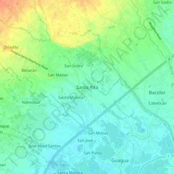
Name: Santa Rita topographic map, elevation, terrain.

Location: Santa Rita, Pampanga, Central Luzon, 2002, Philippines (14.95903 120.57801 15.03903 120.65801)

Average elevation: 13 m

Minimum elevation: -1 m

Maximum elevation: 42 m

Other topographic maps

Click on a map to view its topography, its elevation and its terrain.

Santa Catalina

Philippines > Pampanga > San Luis

Average elevation: 6 m

Gulap

Philippines > Pampanga > Candaba

Average elevation: 7 m

Macabebe

Philippines > Pampanga

Average elevation: 2 m

Lourdes

Philippines > Pampanga > Candaba

Average elevation: 10 m

Gear up for your next adventure:

🧼Biodegradable Soap - Leave-no-trace hygiene for multi-day mountain treks
🧼Technical Clothing Wash - Special soap to clean and restore waterproof membranes
📦Dry Bags - Waterproof bags to protect gear from rain
🥫Expedition Meals - Lightweight, high-calorie nutrition for long-distance hikers
🥾Hiking Boot Waterproofing Wax - Maintain the lifespan of your leather trekking boots

As an Amazon Associate, this site earns from qualifying purchases at no extra cost to you.