Geolocate

Gonbo Rangjon topographic map

Click on the map to display elevation.

About this map

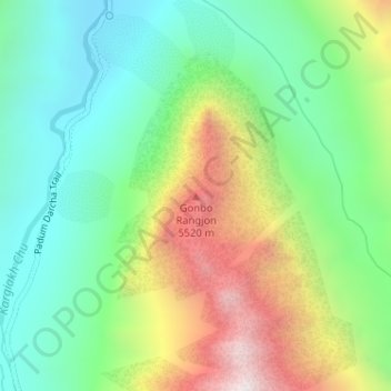
Name: Gonbo Rangjon topographic map, elevation, terrain.

Location: Gonbo Rangjon, Zanskar tehsil, Kargil district, Ladakh, India (32.95698 77.25711 32.95708 77.25721)

Average elevation: 4,759 m

Minimum elevation: 4,340 m

Maximum elevation: 5,513 m

Other topographic maps

Click on a map to view its topography, its elevation and its terrain.

Zanskar

India > Ladakh > Zanskar tehsil

Average elevation: 4,285 m

Gear up for your next adventure:

📕Outdoor Navigation Books - Learn traditional and modern navigation techniques
🔭Compact Hiking Binoculars - Lightweight optics for scouting terrain and spotting wildlife
🖼️Topographic Map Art - Decorative 3D-effect posters of famous UK peaks and regions
🧘Folding Sit Mats - Dry and warm seat for map-reading breaks on damp ground
🧦Merino Wool Hiking Socks - Moisture-wicking socks to prevent blisters during long mountain walks

As an Amazon Associate, this site earns from qualifying purchases at no extra cost to you.