Geolocate

Bedia topographic map

Click on the map to display elevation.

About this map

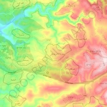
Name: Bedia topographic map, elevation, terrain.

Location: Bedia, Area B, West Bank, 380, Palestinian Territory (32.07472 35.03559 32.15472 35.11559)

Average elevation: 301 m

Minimum elevation: 98 m

Maximum elevation: 488 m

Other topographic maps

Click on a map to view its topography, its elevation and its terrain.

Abu Dis

Palestinian Territory > Area B

Average elevation: 619 m

Abu Dis

Palestinian Territory > Area B

Average elevation: 619 m

Gear up for your next adventure:

🔦Keychain LED Torches - Emergency backup light for finding gear in your pack
🐕Hiking Dog Harnesses - Rugged harnesses for taking your companion on mountain trails
🗺️Scratch-off Peak Maps - Track your progress climbing Munros or Wainwrights
🧥Softshell Jackets - Breathable jackets for active outdoor use
👖Convertible Hiking Trousers - Versatile zip-off pants for changing mountain weather conditions

As an Amazon Associate, this site earns from qualifying purchases at no extra cost to you.