
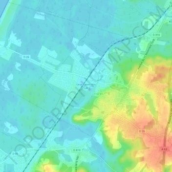
Leus Cases dou Lac topographic map
Interactive map
Click on the map to display elevation.
About this map
Name: Leus Cases dou Lac topographic map, elevation, terrain.
Average elevation: 14 m
Minimum elevation: 0 m
Maximum elevation: 54 m
Other topographic maps
Click on a map to view its topography, its elevation and its terrain.
Le Hameau du Lac
France > Nouvelle-Aquitaine > Landes > Ondres
Le Hameau du Lac, Ondres, Dax, Landes, Nouvelle-Aquitaine, France métropolitaine, 40440, France
Average elevation: 15 m