
Make a donation
Gear up for your next adventure:
As an Amazon Associate, this site earns from qualifying purchases at no extra cost to you.
Thessaly topographic map
Click on the map to display elevation.
Make a donation
Gear up for your next adventure:
As an Amazon Associate, this site earns from qualifying purchases at no extra cost to you.
Thessaly
The region is well delineated by topographical boundaries. The Chasia and Kamvounia mountains lie to the north, the Mount Olympus massif to the northeast. To the west lies the Pindus mountain range, to the southeast the coastal mountains of Óssa and Pelion.
Make a donation
Gear up for your next adventure:
As an Amazon Associate, this site earns from qualifying purchases at no extra cost to you.
About this map
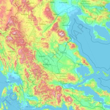
Name: Thessaly topographic map, elevation, terrain.
Location: Thessaly, Thessaly and Central Greece, Greece (38.95462 21.12042 40.19666 24.43312)
Average elevation: 457 m
Minimum elevation: -7 m
Maximum elevation: 2,747 m
Make a donation
Gear up for your next adventure:
As an Amazon Associate, this site earns from qualifying purchases at no extra cost to you.
Other topographic maps
Click on a map to view its topography, its elevation and its terrain.
Pindus
Greece > Thessaly and Central Greece > Karditsa Regional Unit
The Pindus, also Pindos or Pindhos is a mountain range located in Northern Greece and Southern Albania. It is roughly 160 km (99 mi) long, with a maximum elevation of 2,637 metres (8,652 ft) (Mount Smolikas). Because it runs north to south along much of mainland Greece, the Pindus range is known colloquially…
Average elevation: 1,510 m
Zappeion
Greece > Thessaly and Central Greece > Larisa Regional Unit > Municipal Unit of Nikea
Average elevation: 182 m
Saint George
Greece > Thessaly and Central Greece > Larisa Regional Unit > Municipal Unit of Krannon
Average elevation: 210 m
Make a donation
Gear up for your next adventure:
As an Amazon Associate, this site earns from qualifying purchases at no extra cost to you.
Pindus
Greece > Thessaly and Central Greece > Karditsa Regional Unit
The Pindus (also Pindos or Pindhos; Greek: Πίνδος, romanized: Píndos; Albanian: Pindet; Aromanian: Pindu) is a mountain range located in Northern Greece and Southern Albania. It is roughly 160 km (99 mi) long, with a maximum elevation of 2,637 metres (8,652 ft) (Mount Smolikas). Because it runs north to…
Average elevation: 1,510 m
Κοκκινοπηλός
Greece > Thessaly and Central Greece > Larisa Regional Unit > Elassona Municipality
Average elevation: 1,320 m
Kallidromo
Greece > Thessaly and Central Greece > Phthiotis Regional Unit > Municipal Unit of Molos
Average elevation: 356 m
Thiva
Greece > Thessaly and Central Greece > Regional Unit of Boeotia > Municipal Unit of Thebes
Thebes is situated in a plain, between Lake Yliki (ancient Hylica) to the north, and the Cithaeron mountains, which divide Boeotia from Attica, to the south. Its elevation is 215 m (705 ft) above mean sea level. It is about 50 km (31 mi) northwest of Athens, and 100 km (62 mi) southeast of Lamia. The A1…
Average elevation: 218 m
Make a donation
Gear up for your next adventure:
As an Amazon Associate, this site earns from qualifying purchases at no extra cost to you.
Πρόδρομος
Greece > Thessaly and Central Greece > Regional Unit of Boeotia > Δημοτική Ενότητα Θίσβης
Average elevation: 368 m
Sarantaina
Greece > Thessaly and Central Greece > Phthiotis Regional Unit > Municipal Unit of Sperchiada
Average elevation: 1,660 m
Make a donation
Gear up for your next adventure:
As an Amazon Associate, this site earns from qualifying purchases at no extra cost to you.
Kissos
Greece > Thessaly and Central Greece > Regional Unit of Magnesia > Municipal Unit of Mouresi
Average elevation: 482 m
Amfissa
Greece > Thessaly and Central Greece > Regional Unit of Phocis > Municipal Unit of Amfissa
Average elevation: 506 m
Kalypso
Greece > Thessaly and Central Greece > Phthiotis Regional Unit > Municipal Unit of Dafnousia
Average elevation: 54 m
Make a donation
Gear up for your next adventure:
As an Amazon Associate, this site earns from qualifying purchases at no extra cost to you.
Χάνια
Greece > Thessaly and Central Greece > Regional Unit of Magnesia > Volos Municipality
Average elevation: 1,103 m
Kouvelles
Greece > Thessaly and Central Greece > Euboea Regional Unit > Styra Municipal Unit
Average elevation: 131 m
Ύπατο
Greece > Thessaly and Central Greece > Regional Unit of Boeotia > Municipal Unit of Thebes
Average elevation: 251 m
Make a donation
Gear up for your next adventure:
As an Amazon Associate, this site earns from qualifying purchases at no extra cost to you.
Loutropigi
Greece > Thessaly and Central Greece > Karditsa Regional Unit > Municipal Unit of Menelaida
Average elevation: 563 m
Argalasti
Greece > Thessaly and Central Greece > Regional Unit of Magnesia > Municipal unit of Argalasti
Average elevation: 226 m
Pezoula
Greece > Thessaly and Central Greece > Karditsa Regional Unit > Nevropoli Agrafon Municipal Unit
Average elevation: 1,032 m
Pilion
Greece > Thessaly and Central Greece > Regional Unit of Magnesia > Municipal Unit of Mouresi
The mountain is thickly forested, with both deciduous and perennial forests, mainly of beech, oak, maple and chestnut trees, with olive, apple, pear trees and plane tree groves surrounding places with water. Pelion is considered one of the most beautiful mountains in Greece and is a popular tourist attraction…
Average elevation: 1,239 m
Make a donation
Gear up for your next adventure:
As an Amazon Associate, this site earns from qualifying purchases at no extra cost to you.
Δένδρος
Greece > Thessaly and Central Greece > Karditsa Regional Unit > Νεοχώρια
Average elevation: 555 m
Make a donation
Gear up for your next adventure:
As an Amazon Associate, this site earns from qualifying purchases at no extra cost to you.
Gavrina
Greece > Thessaly and Central Greece > Regional Unit of Evrytania > Municipal Unit of Viniani
Average elevation: 1,194 m
Loutra Smokovou
Greece > Thessaly and Central Greece > Karditsa Regional Unit > Municipal Unit of Menelaida
Average elevation: 558 m
Mouresi
Greece > Thessaly and Central Greece > Regional Unit of Magnesia > Municipal Unit of Mouresi
Average elevation: 303 m
Make a donation
Gear up for your next adventure:
As an Amazon Associate, this site earns from qualifying purchases at no extra cost to you.
Skopia
Greece > Thessaly and Central Greece > Larisa Regional Unit > Farsala Municipality
Average elevation: 407 m
Meteora
Greece > Thessaly and Central Greece > Trikala Regional Unit > Kastraki
The Monastery of Rousanou is believed to have been constructed, like many of the other monasteries, in the 14th century. The cathedral is believed to have been built in the 16th century and later decorated in 1540. The name Rousanou is believed to come from the first group of monks who settled on the rock from…
Average elevation: 429 m
Kastania
Greece > Thessaly and Central Greece > Regional Unit of Evrytania > Municipal Unit of Proussos
Average elevation: 868 m
Make a donation
Gear up for your next adventure:
As an Amazon Associate, this site earns from qualifying purchases at no extra cost to you.
Domokos
Greece > Thessaly and Central Greece > Phthiotis Regional Unit > Δημοτική Ενότητα Δομοκού
Average elevation: 440 m
Orchomenos
Greece > Thessaly and Central Greece > Regional Unit of Boeotia > Municipal Unit of Orchomenos
Average elevation: 110 m
Thiva
Greece > Thessaly and Central Greece > Regional Unit of Boeotia > Municipal Unit of Thebes
Thebes is situated in a plain, between Lake Yliki (ancient Hylica) to the north, and the Cithaeron mountains, which divide Boeotia from Attica, to the south. Its elevation is 215 m (705 ft) above mean sea level. It is about 50 km (31 mi) northwest of Athens, and 100 km (62 mi) southeast of Lamia. Motorway 1…
Average elevation: 218 m
Meteora
Greece > Thessaly and Central Greece > Trikala Regional Unit > Kastraki
The Monastery of Rousanou is believed to have been constructed, like many of the other monasteries, in the 14th century. The cathedral is believed to have been built in the 16th century and later decorated in 1540. The name Rousanou is believed to come from the first group of monks who settled on the rock from…
Average elevation: 429 m
Make a donation
Gear up for your next adventure:
As an Amazon Associate, this site earns from qualifying purchases at no extra cost to you.
Δημητριάδα
Greece > Thessaly and Central Greece > Regional Unit of Magnesia > Volos Municipality
Average elevation: 3 m
Σούρπη
Greece > Thessaly and Central Greece > Regional Unit of Magnesia > Municipal Unit of Sourpi
Average elevation: 123 m
Stavros
Greece > Thessaly and Central Greece > Phthiotis Regional Unit > Municipal Unit of Lamia
Average elevation: 84 m
Thiva
Greece > Thessaly and Central Greece > Regional Unit of Boeotia > Municipal Unit of Thebes
Thebes is situated in a plain, between Lake Yliki (ancient Hylica) to the north, and the Cithaeron mountains, which divide Boeotia from Attica, to the south. Its elevation is 215 m (705 ft) above mean sea level. It is about 50 km (31 mi) northwest of Athens, and 100 km (62 mi) southeast of Lamia. Motorway 1…
Average elevation: 218 m
Make a donation
Gear up for your next adventure:
As an Amazon Associate, this site earns from qualifying purchases at no extra cost to you.
Glafki
Greece > Thessaly and Central Greece > Larisa Regional Unit > Municipal Unit of Platykampos
Average elevation: 60 m
Make a donation
Gear up for your next adventure:
As an Amazon Associate, this site earns from qualifying purchases at no extra cost to you.
Σκοπιά
Greece > Thessaly and Central Greece > Regional Unit of Boeotia > Municipal Unit of Akrefnia
Average elevation: 205 m
Milina
Greece > Thessaly and Central Greece > Regional Unit of Magnesia > Sipias Municipal Unit
Average elevation: 81 m
Make a donation
Gear up for your next adventure:
As an Amazon Associate, this site earns from qualifying purchases at no extra cost to you.
Meteora
Greece > Thessaly and Central Greece > Trikala Regional Unit > Kastraki
The Monastery of Rousanou is believed to have been constructed, like many of the other monasteries, in the 14th century. The cathedral is believed to have been built in the 16th century and later decorated in 1540. The name Rousanou is believed to come from the first group of monks who settled on the rock from…
Average elevation: 428 m
Makrinitsa
Greece > Thessaly and Central Greece > Regional Unit of Magnesia > Volos Municipality
Average elevation: 663 m
Agios Ioannis
Greece > Thessaly and Central Greece > Regional Unit of Magnesia > Volos Municipality > Portaria
Average elevation: 815 m
Livadia
Greece > Thessaly and Central Greece > Regional Unit of Boeotia > Levadia Municipal Unit
Average elevation: 313 m
Make a donation
Gear up for your next adventure:
As an Amazon Associate, this site earns from qualifying purchases at no extra cost to you.
Loutra Thermopilon
Greece > Thessaly and Central Greece > Phthiotis Regional Unit > Municipal Unit of Lamia
Average elevation: 241 m
Παρνασσός
Greece > Thessaly and Central Greece > Phthiotis Regional Unit > Municipal Unit of Tithorea
Average elevation: 2,125 m
Όλυμπος
Greece > Thessaly and Central Greece > Larisa Regional Unit > Elassona Municipality
Average elevation: 2,456 m
Ano Volos
Greece > Thessaly and Central Greece > Regional Unit of Magnesia > Volos Municipality
Average elevation: 289 m
Make a donation
Gear up for your next adventure:
As an Amazon Associate, this site earns from qualifying purchases at no extra cost to you.
Make a donation
Gear up for your next adventure:
As an Amazon Associate, this site earns from qualifying purchases at no extra cost to you.
Tanagra
Greece > Thessaly and Central Greece > Regional Unit of Boeotia > Δημοτική Ενότητα Τανάγρας > Tanagra
Average elevation: 231 m
Devil's tower
Greece > Thessaly and Central Greece > Trikala Regional Unit > Kalabaka
Average elevation: 414 m
Λιπιότα
Greece > Thessaly and Central Greece > Trikala Regional Unit > Vrontero
Average elevation: 1,165 m
Make a donation
Gear up for your next adventure:
As an Amazon Associate, this site earns from qualifying purchases at no extra cost to you.
Karpenisi
Greece > Thessaly and Central Greece > Regional Unit of Evrytania > Municipal Unit of Karpenisi
Karpenisi (Greek: Καρπενήσι, Greek pronunciation: [karpeˈnisi]) is a town in central Greece. It is the capital of the regional unit of Evrytania. Karpenisi is situated in the valley of the river Karpenisiotis (Καρπενησιώτης), a tributary of the Megdovas, in the southern part of the…
Average elevation: 1,236 m
Pinios (Thessalia)
Greece > Thessaly and Central Greece > Trikala Regional Unit > Trikala Municipality
Average elevation: 119 m
Make a donation
Gear up for your next adventure:
As an Amazon Associate, this site earns from qualifying purchases at no extra cost to you.