Geolocate

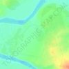
Ramadi topographic map

Click on the map to display elevation.

About this map

Name: Ramadi topographic map, elevation, terrain.

Location: Ramadi, Al-Ramadi Central Subdistrict, Al-Ramadi District, Al-Anbar Governorate, Iraq (33.26599 43.13992 33.58599 43.45992)

Average elevation: 62 m

Minimum elevation: 42 m

Maximum elevation: 112 m

Other topographic maps

Click on a map to view its topography, its elevation and its terrain.
Al-Rutba District

Iraq > Al-Anbar Governorate

Average elevation: 468 m

Al Ubaydi

Iraq > Al-Anbar Governorate

Average elevation: 172 m

Gear up for your next adventure:

🧰Survival Kits - Emergency tools for remote environments
🧼Camping Hygiene Kits - Compact hygiene essentials for outdoor stays
🐕Hiking Dog Harnesses - Rugged harnesses for taking your companion on mountain trails
👖Packable Overtrousers - Quick-deploy rain protection for legs in sudden storms
🛰️Handheld GPS Devices - Reliable GPS units for hiking and outdoor navigation

As an Amazon Associate, this site earns from qualifying purchases at no extra cost to you.