Geolocate

Calca topographic map

Click on the map to display elevation.

About this map

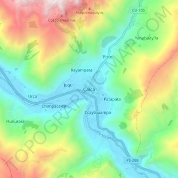
Name: Calca topographic map, elevation, terrain.

Location: Calca, Province of Calca, Cusco, 08120, Peru (-13.36168 -71.99601 -13.28168 -71.91601)

Average elevation: 3,523 m

Minimum elevation: 2,907 m

Maximum elevation: 4,752 m

Gear up for your next adventure:

🍱Food Containers - Reusable containers for outdoor meals
🥫Expedition Meals - Lightweight, high-calorie nutrition for long-distance hikers
🛰️Handheld GPS Devices - Reliable GPS units for hiking and outdoor navigation
🧘Folding Sit Mats - Dry and warm seat for map-reading breaks on damp ground
🪓Outdoor Multitools - Versatile tools for hiking and camping

As an Amazon Associate, this site earns from qualifying purchases at no extra cost to you.