
Make a donation
Gear up for your next adventure:
As an Amazon Associate, this site earns from qualifying purchases at no extra cost to you.
Flagstaff topographic map
Click on the map to display elevation.
Make a donation
Gear up for your next adventure:
As an Amazon Associate, this site earns from qualifying purchases at no extra cost to you.
Flagstaff
Flagstaff, the county seat of Coconino County. According to the United States Census Bureau, the city has a total area of 63.9 square miles (165.5 km2), of which only 0.03 square miles (0.08 km2) (0.08%) is water. Flagstaff lies at approximately 7,000 feet (2,130 m) elevation, and is surrounded by the largest contiguous ponderosa pine forest in North America. It is in a mountainous area, and lies along the Rio de Flag watercourse. It is about 130 miles (210 km) north of the State capital, Phoenix.
Make a donation
Gear up for your next adventure:
As an Amazon Associate, this site earns from qualifying purchases at no extra cost to you.
About this map
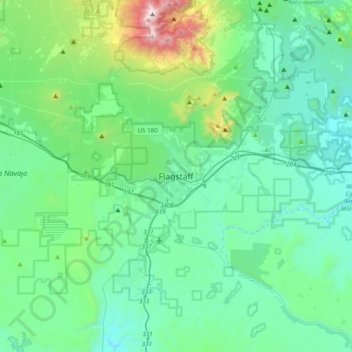
Name: Flagstaff topographic map, elevation, terrain.
Location: Flagstaff, Coconino County, Arizona, 86001, United States (35.03875 -111.81182 35.35875 -111.49182)
Average elevation: 2,230 m
Minimum elevation: 1,895 m
Maximum elevation: 3,836 m
Make a donation
Gear up for your next adventure:
As an Amazon Associate, this site earns from qualifying purchases at no extra cost to you.
Other topographic maps
Click on a map to view its topography, its elevation and its terrain.
Walnut Canyon National Monument
United States > Arizona > Coconino County > Flagstaff
Walnut Canyon National Monument (Hopi: Wupatupqa) is a United States National Monument located about 10 mi (16 km) southeast of downtown Flagstaff, Arizona, near Interstate 40. The canyon rim elevation is 6,690 ft (2,040 m); the canyon's floor is 350 ft (110 m) lower. A 0.9 mi (1.4 km) long loop trail descends…
Average elevation: 1,968 m