
Goßmannsdorf topographic map
Interactive map
Click on the map to display elevation.
About this map
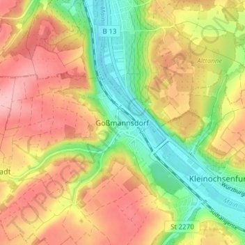
Name: Goßmannsdorf topographic map, elevation, terrain.
Average elevation: 246 m
Minimum elevation: 172 m
Maximum elevation: 315 m
Vom 14. bis ins 19. Jahrhundert hatte der Ort eine geschlossene Dorfbefestigung, die aus einer Ringmauer mit drei großen und sieben kleinen Türmen bestand. Sie ist nur noch teilweise in ihrer alten Höhe erhalten.
Other topographic maps
Click on a map to view its topography, its elevation and its terrain.
Darstadt
Deutschland > Bayern > Landkreis Würzburg > Ochsenfurt
Darstadt, Ochsenfurt, Landkreis Würzburg, Bayern, Deutschland
Average elevation: 278 m
Darstadt
Deutschland > Bayern > Landkreis Würzburg > Ochsenfurt > Darstadt
Darstadt, Ochsenfurt, Landkreis Würzburg, Bayern, 97286, Deutschland
Average elevation: 279 m