
Union topographic map
Interactive map
Click on the map to display elevation.
About this map
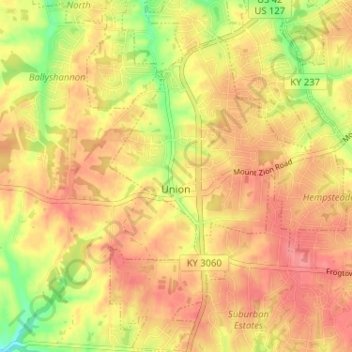
Name: Union topographic map, elevation, terrain.
Location: Union, Boone County, Kentucky, 41091, United States (38.92267 -84.69260 38.97267 -84.64923)
Average elevation: 265 m
Minimum elevation: 220 m
Maximum elevation: 290 m
Other topographic maps
Click on a map to view its topography, its elevation and its terrain.
Burlington
United States > Kentucky > Boone County
Burlington, Boone County, Kentucky, 41005, United States
Average elevation: 250 m
Hebron
United States > Kentucky > Boone County
Hebron, Boone County, Kentucky, 41048, United States
Average elevation: 263 m
Verona
United States > Kentucky > Boone County
Verona, Boone County, Kentucky, 41092, United States
Average elevation: 259 m
Florence
United States > Kentucky > Boone County
Florence, Boone County, Kentucky, 41042, United States
Average elevation: 265 m
Walton
United States > Kentucky > Boone County
Walton, Boone County, Kentucky, United States
Average elevation: 264 m
Big Bone Lick State Park
United States > Kentucky > Boone County > Big Bone
Big Bone Lick State Park, Big Bone, Boone County, Kentucky, United States
Average elevation: 179 m