Geolocate

Westbrook topographic map

Click on the map to display elevation.

About this map

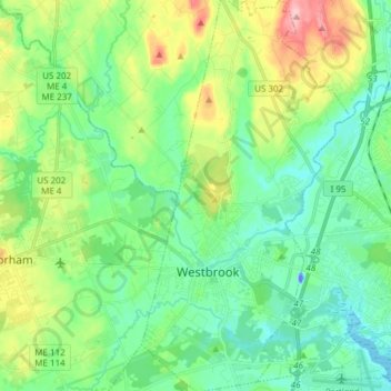
Name: Westbrook topographic map, elevation, terrain.

Location: Westbrook, Cumberland County, Maine, 04092, United States (43.64245 -70.39224 43.75382 -70.31112)

Average elevation: 40 m

Minimum elevation: -11 m

Maximum elevation: 142 m

Other topographic maps

Click on a map to view its topography, its elevation and its terrain.

Bay of Naples

United States > Maine > Cumberland County > Naples

Average elevation: 102 m

Deep Cut

United States > Maine > Cumberland County > Brunswick

Average elevation: 40 m

Gear up for your next adventure:

👕Merino Base Layers - Natural temperature regulation for cold weather hiking and camping
🧥Waterproof Hiking Jackets - Rain protection for walking in all weather conditions
🧤Waterproof Overmitts - Extreme weather protection for hikers and mountaineers
📍Handheld GPS Navigators - Reliable satellite navigation for hiking and off-road exploration
🥾Trekking Poles - Poles to improve stability on uneven terrain

As an Amazon Associate, this site earns from qualifying purchases at no extra cost to you.