Geolocate

Burr Ridge topographic map

Click on the map to display elevation.

About this map

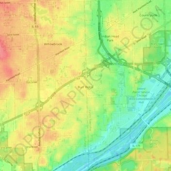
Name: Burr Ridge topographic map, elevation, terrain.

Location: Burr Ridge, DuPage County, Illinois, 65027, United States (41.71228 -87.94522 41.78957 -87.89267)

Average elevation: 209 m

Minimum elevation: 177 m

Maximum elevation: 242 m

Other topographic maps

Click on a map to view its topography, its elevation and its terrain.

Elmhurst

United States > Illinois > DuPage County

Due to local topography, the town has had a tendency to flood in the past after large rainfalls; the city is currently undertaking a large effort to mitigate future flooding.

Average elevation: 207 m

Morton Arboretum

United States > Illinois > DuPage County > Lisle

Average elevation: 220 m

Elmhurst

United States > Illinois > DuPage County

Due to local topography, the town has had a tendency to flood in the past after large rainfalls; the city is currently undertaking a large effort to mitigate future flooding.

Average elevation: 207 m

Wheaton

United States > Illinois > DuPage County

Average elevation: 232 m

Elmhurst

United States > Illinois > DuPage County

Due to local topography, the town has had a tendency to flood in the past after large rainfalls; the city is currently undertaking a large effort to mitigate future flooding.

Average elevation: 207 m

Medinah

United States > Illinois > DuPage County

Average elevation: 225 m

Gear up for your next adventure:

🔋Rechargeable Batteries - Eco-friendly power for headlamps and older GPS units
🎒Hiking Daypacks (20L) - Compact backpacks for day trips and technical mountain ascents
📐Altimeters & Barometers - Tools for measuring altitude and air pressure
🧢Hiking Hats - Sun and weather protection for outdoor walks
🧷Tenacious Repair Tape - Instant fix for torn tents, jackets, or dry bags

As an Amazon Associate, this site earns from qualifying purchases at no extra cost to you.