
Make a donation
Gear up for your next adventure:
As an Amazon Associate, this site earns from qualifying purchases at no extra cost to you.
Timmus Lake topographic map
Click on the map to display elevation.
Make a donation
Gear up for your next adventure:
As an Amazon Associate, this site earns from qualifying purchases at no extra cost to you.
About this map
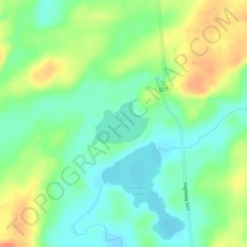
Name: Timmus Lake topographic map, elevation, terrain.
Average elevation: 461 m
Minimum elevation: 441 m
Maximum elevation: 491 m
Make a donation
Gear up for your next adventure:
As an Amazon Associate, this site earns from qualifying purchases at no extra cost to you.
Other topographic maps
Click on a map to view its topography, its elevation and its terrain.
Wapikaimaski Lake
Canada > Ontario > Thunder Bay District > Unorganized Thunder Bay District
Average elevation: 437 m
Lac des Mille Lacs
Canada > Ontario > Thunder Bay District > Unorganized Thunder Bay District
Average elevation: 469 m
Tower Mountain
Canada > Ontario > Thunder Bay District > Unorganized Thunder Bay District
Average elevation: 575 m
Lower Ross Lake
Canada > Ontario > Thunder Bay District > Unorganized Thunder Bay District
Average elevation: 393 m
Make a donation
Gear up for your next adventure:
As an Amazon Associate, this site earns from qualifying purchases at no extra cost to you.
Quint Island Lake;Shacabac Creek
Canada > Ontario > Thunder Bay District > Unorganized Thunder Bay District
Average elevation: 283 m
Upsala
Canada > Ontario > Thunder Bay District > Unorganized Thunder Bay District
Average elevation: 487 m
Whitefish Lake
Canada > Ontario > Thunder Bay District > Unorganized Thunder Bay District > Suomi
Average elevation: 456 m
Shebandowan
Canada > Ontario > Thunder Bay District > Unorganized Thunder Bay District
Average elevation: 461 m
Make a donation
Gear up for your next adventure:
As an Amazon Associate, this site earns from qualifying purchases at no extra cost to you.
Nolalu
Canada > Ontario > Thunder Bay District > Unorganized Thunder Bay District
Average elevation: 370 m
Arrow Lake
Canada > Ontario > Thunder Bay District > Unorganized Thunder Bay District
Average elevation: 521 m
Pass Lake
Canada > Ontario > Thunder Bay District > Unorganized Thunder Bay District
Average elevation: 259 m
Miniss Lake
Canada > Ontario > Thunder Bay District > Unorganized Thunder Bay District
Average elevation: 394 m
Make a donation
Gear up for your next adventure:
As an Amazon Associate, this site earns from qualifying purchases at no extra cost to you.
Sleeping Giant Provincial Park
Canada > Ontario > Thunder Bay District > Unorganized Thunder Bay District
Average elevation: 204 m
Perute Lake
Canada > Ontario > Thunder Bay District > Unorganized Thunder Bay District
Average elevation: 410 m
Harvey Lake
Canada > Ontario > Thunder Bay District > Unorganized Thunder Bay District
Average elevation: 297 m
Sunshine
Canada > Ontario > Thunder Bay District > Unorganized Thunder Bay District
Average elevation: 401 m
Make a donation
Gear up for your next adventure:
As an Amazon Associate, this site earns from qualifying purchases at no extra cost to you.
Horne Creek;Horne Lake
Canada > Ontario > Thunder Bay District > Unorganized Thunder Bay District
Average elevation: 443 m
Ruffle Lake
Canada > Ontario > Thunder Bay District > Unorganized Thunder Bay District
Average elevation: 326 m
Kapikotongwa River
Canada > Ontario > Thunder Bay District > Unorganized Thunder Bay District
Average elevation: 268 m
DeCourcey Lake
Canada > Ontario > Thunder Bay District > Unorganized Thunder Bay District
Average elevation: 457 m
Make a donation
Gear up for your next adventure:
As an Amazon Associate, this site earns from qualifying purchases at no extra cost to you.
Shabaqua Corners
Canada > Ontario > Thunder Bay District > Unorganized Thunder Bay District
Average elevation: 416 m
Rossport
Canada > Ontario > Thunder Bay District > Unorganized Thunder Bay District
Average elevation: 227 m
Springpole Island
Canada > Ontario > Thunder Bay District > Unorganized Thunder Bay District
Average elevation: 289 m
Burness Lake
Canada > Ontario > Thunder Bay District > Unorganized Thunder Bay District
Average elevation: 301 m
Make a donation
Gear up for your next adventure:
As an Amazon Associate, this site earns from qualifying purchases at no extra cost to you.
North Lake
Canada > Ontario > Thunder Bay District > Unorganized Thunder Bay District
Average elevation: 523 m
Whitesand Lake
Canada > Ontario > Thunder Bay District > Unorganized Thunder Bay District
Average elevation: 318 m
Georgia Lake
Canada > Ontario > Thunder Bay District > Unorganized Thunder Bay District
Average elevation: 459 m
Rossport
Canada > Ontario > Thunder Bay District > Unorganized Thunder Bay District
Average elevation: 227 m
Make a donation
Gear up for your next adventure:
As an Amazon Associate, this site earns from qualifying purchases at no extra cost to you.
Sleeping Giant Provincial Park
Canada > Ontario > Thunder Bay District > Unorganized Thunder Bay District
Average elevation: 204 m
District Lake
Canada > Ontario > Thunder Bay District > Unorganized Thunder Bay District
Average elevation: 481 m