Geolocate

Wysokin topographic map

Interactive map

Click on the map to display elevation.

About this map

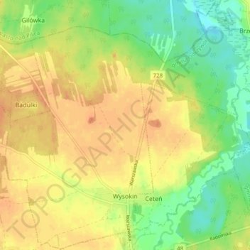
Name: Wysokin topographic map, elevation, terrain.

Location: Wysokin, gmina Odrzywół, Przysucha County, Masovian Voivodeship, 26-425, Poland (51.52147 20.51703 51.56790 20.59222)

Average elevation: 152 m

Minimum elevation: 130 m

Maximum elevation: 169 m

Other topographic maps

Click on a map to view its topography, its elevation and its terrain.

Podczasza Wola

Poland > Masovian Voivodeship > Przysucha County

Podczasza Wola, gmina Klwów, Przysucha County, Masovian Voivodeship, Poland

Average elevation: 168 m

Kozłowiec

Poland > Masovian Voivodeship > Przysucha County

Kozłowiec, gmina Przysucha, Przysucha County, Masovian Voivodeship, Poland

Average elevation: 264 m

Przysucha

Poland > Masovian Voivodeship > Przysucha County > Przysucha > Przysucha

Przysucha, gmina Przysucha, Przysucha County, Masovian Voivodeship, 26-400, Poland

Average elevation: 227 m

Ruski Bród

Poland > Masovian Voivodeship > Przysucha County

Ruski Bród, gmina Przysucha, Przysucha County, Masovian Voivodeship, Poland

Average elevation: 269 m